Counting sheep

“Ewe lookin’ at me?”

(Sorry, sometimes I can’t help myself.) Over several years, in all the times I’d visited Anza-Borrego Desert State Park, I had never seen the sheep for which the park is partly named (“lamb” in Spanish is borrego). I first saw a few sheep in March, from afar, as I posted then. In June, on my way home from a board meeting, I saw a ewe atop a crest in the park. Again, from afar.

On Sunday, I joined volunteers helping in the 44th annual Sheep Count at the park. Several dozen volunteers went out to 20 different sites in the park for 2 1/2 days to find and count sheep to help monitor the park’s herd of this endangered subspecies – the Peninsular Desert Bighorn Sheep. Many hiked out each morning to their site, but others backpacked out and stayed at their remote site from Thursday night to Sunday midday. Some sites required hikes of up to six hours to reach them.

The three volunteers I joined had hiked out in the park, observing sheep, on both the Friday and Saturday before, for 10 hours each day. I was the dilettante, coming in for the final day, and a half-day at that.

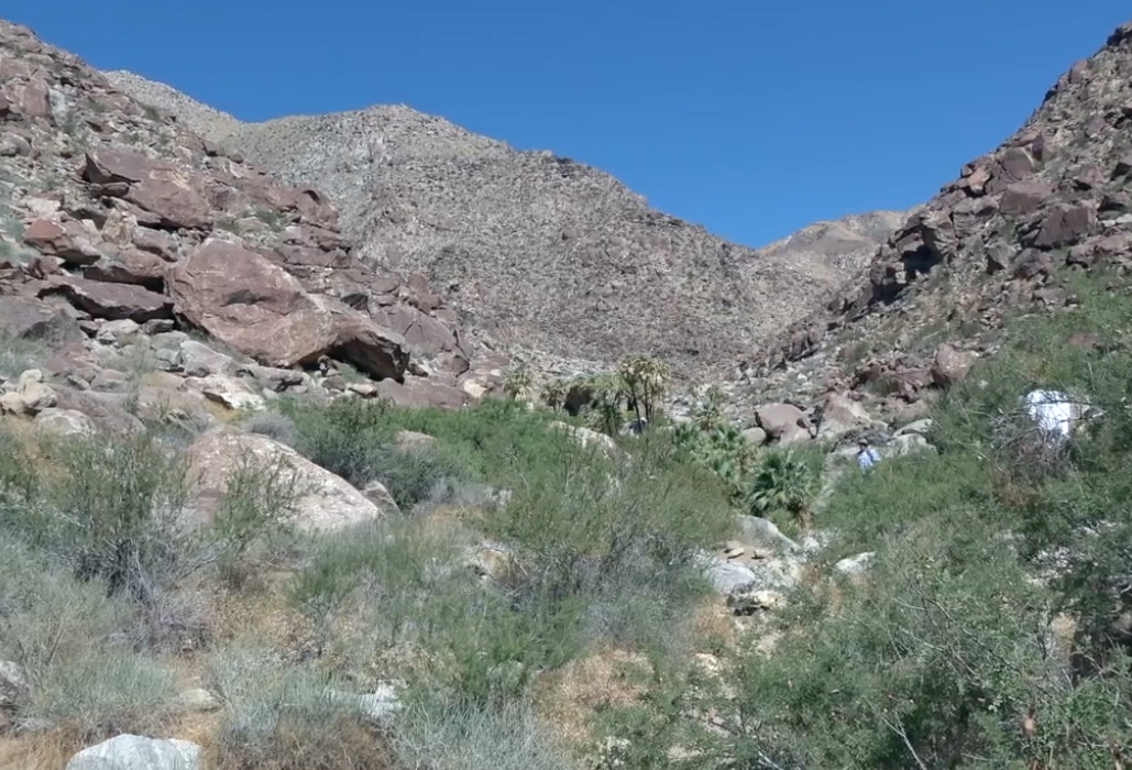
Our location was Borrego Palm Canyon, 1st Grove. The set of palm trees in the center, rear, is the first of three palm groves in the canyon. There were sheep-counters at the second and third groves as well, hours further into the canyon and with no trail.

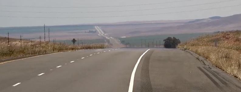
It took about 45 minutes to hike into the canyon. I was glad that I had a guide with me, because, for periods of time, it was unclear to me where the “trail” was. I had never been out here, though it is the most popular trail in the park, because it is so “easy.” I had a rather naive notion of what an “easy” trail would be like. I was lugging a camp chair, camera equipment (including a tripod), a few containers of water, and more. As you’ll see in the video (of course there’s a video), the trail was at times not flat. (According to my iPhone, for the day, I walked 4.2 miles, taking 12,119 steps, and climbed 13 floors. For some of you, that approaches a normal day. For me, it was very much an outlier. It was in the 80s when we went in around 6:30 am and about 105 coming out midday.)

I was told there was no guarantee that I would see any sheep. Several groups of volunteers indeed reported no sightings for the entire weekend. But I hit the jackpot. Not only 15-18 sheep, but some quite close.

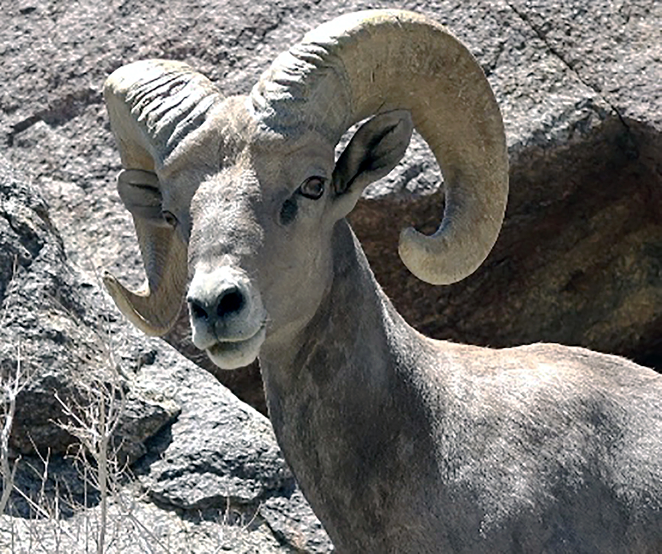
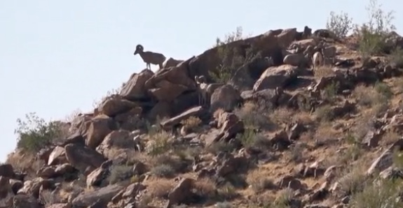
The sheep didn’t start to appear until close to 8 am. The volunteers said they actually seemed to be late sleepers. We had seen hikers in the early morning draw a blank in terms of sheep sightings. Ewes, I was told, usually appeared first and rams followed. This screen capture profiles a solitary ewe near the top of the hillside, but there are several rams below her. I did not see the rams at the time and could discern them only when I watched the video. As you might expect, the sheep blend rather well into their environment.

In one instance, I could have been a YouTube hero . . . and a likely patient in the hospital, if I was lucky. Standing on the trail with another volunteer, we heard sounds from around a curve. My companion said, “Those are not human.” Suddenly, what were hoofsteps were quicker and louder and a ram charged around the corner of the trail, heading right at me. I can still see the headlights of that approaching train, but only in my mind’s eye. I lowered the video camera and jumped off the trail. The ram veered off as well.

Palm Canyon is much more “verdant” than in previous years, because of the above-average rainfall. Hard to imagine, but many of the boulders strewn about the canyon floor had been carried there by massive floods, from centuries, eons ago.

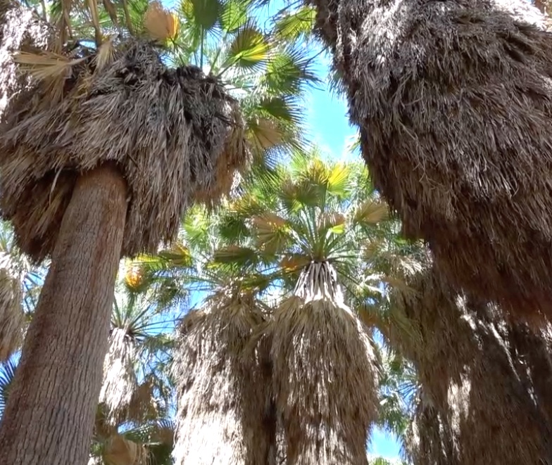
The sheep drink out of rivulets of water that come down from the palm grove (inside view, at left). First Grove contains a pool of water, but the sheep avoid the grove as it provides cover for potential predators, i.e., mountain lions. The sheep seem rather oblivious to people. They are used to them in this canyon, because of its popularity. And there is the thought they realize mountain lions avoid humans, so it is better to be out and about when humans are as well.

This video is less formal than the one I prepared for the Anza-Borrego Foundation. That one contains a bit more on what the counters do and the scientific aspect of the project. I hope you enjoy this view of the sheep and their world. (I recommend watching on your device with the biggest screen, not a phone.)

USMC amphibious demo

USS San Diego off Red Beach

Yesterday, Flag Day, I was privileged to be among those attending a training evolution and demonstration of the Marine Air-Ground Task Force (MAGTF) concept. It took place on “the beach” at Camp Pendleton.

The event was part of Camp Pendleton’s celebration this year of its 75th anniversary and members of the community were invited to watch and learn more about the Marines and the base. I was there as a member of the local council of the Navy League, along with members of other councils.

In simple terms, MAGTF involves Navy and Marine forces — air, ground, and sea — in a coordinated amphibious operation. Navy ships bring materiel and personnel to the area, land Marines and their equipment and supplies, supported by Navy and Marine aircraft.

Medium howitzer

The event was much less whiz-bang than similar demonstrations at the annual airshow (a video of that portion of the 2014 airshow is at the end of this post), but the scale and kinds of equipment were quite different. The Camp Pendleton evolution involved Navy ships, amphibious craft, and an actual amphibious landing on an awesome stretch of sand and waves.

Here’s a video (7:00) of highlights.

The presentation also included briefings on the base itself. Camp Pendleton covers more than 125,000 acres, or just over 195 square miles. Its coastline (17.5 miles) is about the same length as New Hampshire’s. The base goes 10+ miles inland. Because of its size and location, Camp Pendleton is the only military facility in the US that allows for large-scale operations combining air, sea, and ground forces. Jet aircraft, for example, are nearly unrestricted in their operations over this area.

There are about 40,000 active duty Marines, and some Navy sailors, at Camp Pendleton on any given day. Combining family members and civilian employees, the base population on a workday is about 80,000. (Also using the base commissary, exchange, etc., are many of the approximately 80,000 retired military who live within a 50-mile radius. Including me.)

There are signs on I-5, which goes north-south up the coastline here, that say “Camp Pendleton — Preserving California’s precious resources.” That, of course, is not the purpose of Camp Pendleton, but it is the result in many cases. Without Camp Pendleton, there would be little open space between LA and San Diego. As one approaches the end of Camp Pendleton in either direction on I-5, the visual demarcation between it and San Clemente to the north or Oceanside to the south is dramatic and striking.

Just looking at the beach in the video, you can see that, with the exception of amphibious vehicles :), it’s pretty pristine. No condos lining the bluffs, etc. Camp Pendleton’s mix of beaches, bluffs, mesas, canyons, and mountains, along with the only free-flowing river in Southern California (Santa Margarita), allows one to see what this region would look like, absent several million people.

Pacific pocket mouse

That ecosystem includes more than 1,000 species of plants, fish, and animals. Eighteen of those species are endangered and there are several that exist only on the base. The colonel who headed up the event said the road we used to walk to the observation bluff could not be improved, because it would disturb the habitat of the Pacific pocket mouse, which is endangered. Indeed, the Marines were not allowed to remove a large piece of twisted metal from the area because the mice had made it part of their habitat.

Below is the video of the MAGTF display at the 2014 airshow at Marines Corps Air Station, Miramar. (Years ago, when it was a Naval Air Station, it was the location for Top Gun, the aviation training program as well as the movie.) Action starts at the 1:09 mark.


Asilomar – awesome nature, historic architecture

It’s a somewhat contrived name, combining two Spanish words, to represent “refuge by the sea.” Asilomar (a-SIL-o-mar), in reality, is also a beautiful, historic place on the Monterey Peninsula where I was fortunate to spend a few days in mid-April.

I attended a conference sponsored by California State Parks, held at the Asilomar State Beach and Conference Grounds, which is a state parks facility, in Pacific Grove, just south of Monterey. People attending represented the State Parks office and those non-profit associations that are the official partners of state parks. As vice president of the board of the Anza-Borrego Foundation (ABF), partner of the Anza-Borrego Desert State Park, I was among them. Whoda thunk it? (I was only there because ABF did not then have an executive director in place . . . and I had the time.)

But it’s the place, not the conference, on which I want to focus here. And by place, I refer both to the grounds and buildings of the Conference Center as well as the State Beach. The coastline of and sea around the Monterey Peninsula are as awesome as you would expect, but you may be unfamiliar with Asilomar’s historic element.

Julia Morgan

Familiar with the name Julia Morgan? Or American Craftsman style of architecture? Or the Arts and Crafts Movement? Asilomar is a blend of the three. Julia Morgan is well known in California as one of the foremost architects of the first half of the 20th Century. I urge you to do more research online about her and her work. Her name is familiar to me, as she worked on the design of several buildings/structures on the UC Berkeley campus, where I worked for a dozen years, and in the Berkeley/Oakland area.

A Berkeley graduate (1894) in engineering, Morgan became the first woman to become a licensed architect in California in 1904. Through her work at Berkeley, Morgan became known to Phoebe Apperson Hearst, principal patron of the Berkeley campus. Hearst was also a patron of the YWCA, which was seeking land for a campground. With Hearst’s assistance, the YWCA received a donation of 30 acres in Pacific Grove in 1913. Morgan was asked by Hearst to design the camp grounds and buildings.

Morgan used a style blending elements of the Arts and Crafts Movement and American Craftsman style, emphasizing nature, the qualities of the land, and local materials. As you’ll see in the video at the end (13:38), the buildings are generally strongly horizontal, with wood and stone predominating.

There are lots of windows and interiors feature exposed beams instead of ceilings. Just about every original building features a large stone fireplace, not only for heat but as a place to gather.

Three original main buildings surround a campus circle. They are Crocker Dining Hall, representing sustenance; Hearst Hall, offering a place for social activities; and Dodge Chapel, for spiritual uplift. Other buildings provided for recreation and served as residences for campers and counselors. The state has since expanded the facilities to enable more conference attendees. The newer buildings are in similar style and rooms are somewhat spare – no telephones or televisions. There is wi-fi.

Morgan worked on Asilomar for 15 years, finishing in 1928. She had many more projects going on and to do. In all, she designed more than 700 buildings in California. In 1919, Phoebe Apperson Hearst’s son, Willam Randolph Hearst, selected Morgan to do up a little thing called La Cuesta Encantada, better known now as Hearst Castle. She designed and worked on that project for nearly 30 years.

The State of California purchased the YWCA property in 1956, less than a year before Morgan’s death. In 1987, Asilomar was designated a National Historic Landmark for its architecture and in the context of Morgan’s career. Just three years ago, in 2014, the American Institute of Architects awarded its Gold Medal to Julia Morgan, the first woman to be so honored . . . belatedly.

The environment in which this historic facility is located is breath-taking. That’s in the video below – not just visually, but aurally. The views are spectacular and the sound is a roar. You’ll see shorebirds, sand dunes, plant life (somewhat surprisingly similar to the desert) and crashing waves that seem always turned up to 11 in volume. (Weather conditions changed over the three days I was there, and the video is not linear in time. So you’ll see different conditions at different times.)

Getting to and from Asilomar wasn’t easy, but it brought me to a part of California to which I had never been – the western side of the Central Valley, west of Bakersfield. I still get surprised by California’s scale and the size of its emptiness, its wildness. This map gives some geographical context and the highlighted area (approximate) is offered in more detail.

Not that there’s much to detail. You’ll see how open and “empty” this expanse is. What would “normally” take about seven hours driving (440 miles each way, just about the same as Boston-Washington, DC) took me nine hours in each direction, because of LA traffic.

Again, though, some amazing views, surprising roadside installations, and the site of the last scene of a 1950s movie icon.

It’s California.